Driving out to Fuhrman Boulevard, two questions come to mind. The first is pretty common around Buffalo, and it is, "What was here?" The second is more optimistic, and unfortunately, we're still years away from asking it about certain parts of the city; "What is going to be here?"
Despite the great difference in proposal ideas, they all share one thing in common: vision for a large empty space (See Photo 1).
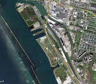 |
| Photo 1: Google Map image of northern sections of "Outer Harbor" |
The second section is the portion of greatest interest, and already has seen some interesting development. Just this month a new park opened along the slip adjacent to Times Beach, containing unique landscape features and a new boat dock. With the exception of the Greenway Trail bike path that runs along the shore, the rest of the land to the south is vacant. The expansive nature of the area prompts the question; what was here before?
For much of it's history, however, there really wasn't much on the Outer Harbor. Bordered by Lake Erie and the City Ship Canal, the Outer Harbor largely provided ancillary shipping services to the nearby grain elevators and industrial activities in Buffalo. Indeed, in 1890, aside from the Connecting Terminal "Elevator A," and a few lonely dwellings along the water, there wasn't much on the outer harbor other than rail lines.
 |
| Photo 2: This image from the 1889-1893 Sanborn map shows the historic width and use of the Outer Habor |
As the Twentieth-Century progressed, and Buffalo maintained its role as the shipping gateway to the west, the development of the Outer Harbor continued. More houses were built along the rail lines, and near Elevator A two large slips were created between 1916 and 1940 to jut out into Lake Erie (See Photo 3). One was owned by the "Buffalo Marine Construction Company," one of the largest shipbuilding interests in the United States by the 1920s, and the other by the City of Buffalo, which sat adjacent to the portion of the harbor used as a city dump.
 |
| Photo 3: Development of Buffalo Marine Construction Company's slip, From 1916-1940 Sanborn Fire Insurance Maps |
 |
| Photo 4: The two slips, as they appear today, with City Dump to the south. |
 |
| Photo 5: A huge portion of the Outer Harbor is contaminated land and has been targeted in several Brownfield Opportunity Area (BOA) studies |
Which, of course, leads to the second question: What is going to be here?
The Department of Transportation's choice to elevate Route 5 landed the Outer Harbor on the Project for Public Space's Hall of Shame. This decision not only squandered dozens of acres perfect for redevelopment, particularly with the transformation of Fuhrman Boulevard into a parkway immediately adjacent, but failed to rectify the issue of access, as the South Michigan Street bridge was removed after it stopped working sometime in the last half-century. The Outer Harbor is currently only accessible via Route 5 or Ohio Street, neither of which are pedestrian or bike friendly.
According to a study in 2010, many of the problems listed above are the biggest challenges for redevelopment: the stigma of waste contaminated soil, the issue of access that limits both residential and tourism opportunities, and the brutal winter wind that would have required the inhabitants of those few structures in 1890 to be hearty individuals indeed. Another issue is the location between Tift Nature Preserve and Times Beach, making any future development (other than a park) problematic for migratory birds, amphibians, and aquatic animals.
The Greenway Trail opened in 2008, and the pricetag gives a glimpse of what a restoration of the remainder of the brownfield may cost. Covering only a portion of the 120-acre parcel, the bike path and remediated soil cost a total of $13.5 million, and though many landscape features currently exist, including berms and trees, the a full-remediation would be necessary to build confidence in the safety of the site. A park would likely require less remediation, accommodate the migratory species nearby, as well as be a welcome public amenity, particularly considering the popularity of the new Outer Harbor concert series.
Written by Derek King, an Architectural Historian at Preservation Studios
The issue of the Skyway has been beaten to death around Buffalo, and the country. It persists as an important question, however as activity in the Canalside and in Larkinville has increased speculation about the Outer Harbor, coinciding with the greatest enthusiasm and activity towards downtown in 60 years. In a perfect storm of opportunity, the expansion of the BNMC and the promise of the "Buffalo Billion," offer a great chance to capitalize off this enthusiasm and make key structural and infrastructural changes that will last long after 2020. Buffalo has a short window to change not only the landscape of downtown and the harbor, but to lay the groundwork that will help change impressions of the city in the decades to come.
Just like the contaminated soil in the Outer Harbor, there is no quick fix to Buffalo's problems, many of which were caused by entities and people that have since disappeared alongside the city's industrial past.
There are however, more ideal solutions, which may take more time and money, but just like those brownfields, it's not just about looking five years into the future, but considering how these decisions will improve the quality of life for Buffalonians for generations to come.
Written by Derek King, an Architectural Historian at Preservation Studios
No comments:
Post a Comment