Written by Derek King, Architectural Historian at Preservation Studios.
In August of 2012, an urban explorer who runs the blog "Concrete Aperture" explored the tunnels that comprise the capped stretch of Scajacuada Creek. The blogger and his friend traversed the three miles of capped creek from Forest Lawn to the edge of Buffalo, documenting the smells, sounds, and sights (or lack there of, in the pitch-black darkness), of one of the most curious urban planning decisions in Buffalo's history.
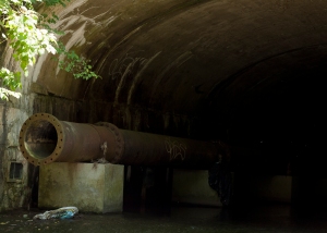
- Entrance to the capped section of the Scajacuada Creek, from Concrete Aperture's exploration of the tunnels.

In 1921, the City of Buffalo responded to the concerns of citizens in the quickly multiplying urban developments of the city's East Side. The Scajacuada Creek, a tributary that flowed westward from the surrounding towns out to the Niagara River, was being polluted by nearby factories, overflowing waste, and negligent homeowners. Rather than address the reasons why the creek was contaminated, and thus, smelled awfully, the City decided to construct a concrete cap over the three mile stretch from the city's Largest Cemetery all the way out to Cheektowaga. Constructed at the height of Buffalo's wealth, the capping of the Scajacuada was an engineering feat, but an irresponsible and wasteful one that defines the blunders of Buffalo's planning history.
Many of Buffalo's decisions over the last century followed similar simplistic logic. Like many cities, Buffalo pursued the easiest solutions to problems rather than the most correct ones. The city ran highways through parkland, and railways through neighborhoods. They let 500,000 square foot factories emerge right next to schools. They demolished entire blocks of buildings in order to combat blight, without any plan to address the poverty that leads to it in the first place. From 1920 until 1980, the actions of Buffalo's planners, whether pushed by modernist hubris or by an automobile-based planning ideology, irreparably harmed the landscape of the city.
If the capping of the Scajacuada Creek represents the modern ideal that there is a man-made solution to any natural "problem", the created of the Scajacuada Expressway represents the sacrifices made to appease car-dependent citizens in the years after the Second World War. Route-198 was finished in 1961, connecting the Niagara Thruway (which runs along the waterfront) with Route 33, an urban arterial that was finished around the time as the Scajacuada and runs downtown. The NY-198 corridor has been praised as one of the only east-west corridors through the city, but at what cost?
The route runs through the middle of Delaware Park, the heart of Olmsted's Parkway System here in Buffalo. Frederick Law Olmsted, designer of Central Park in New York City, chose Buffalo to highlight the true capabilities of urban parks. His parkway system here connected the entire city to the large Delaware Park, running wide tree-lined boulevards and large-roundabouts through neighborhoods, all leading back to "The Park."
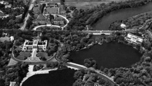
- Aerial Photograph of Elmwood Avenue and Delaware Park prior to the creation of the Scajacuada Expressway

Combined, the creation of the NY-198 and the NY-33 represent two of the most irresponsible blunders on the part of Buffalo planners in the past. The NY-33, or “The Kensington Expressway,” created a rift through one of the city’s most affluent African American neighborhoods, creating a literal canyon down what had been Olmsted’s most glorious parkway in the city. The Scajacuada Expressway bisects Delaware Park with a four-lane highway in the middle of one of Buffalo’s best public spaces, and then runs along and over the western terminus of the Scajacuada Creek.
Together, the condition of Scajacuada Creek and the fate of route NY-198 are intricately tied, as citizen-groups advocate not only for the remediation of the waterway, but the downgrading of the highway, if not its outright removal. Though representative of much larger issues in Buffalo (aging and disruptive infrastructure, and neglected natural resources), these two campaigns signify the growing trend in Buffalo to not blindly accept the mistakes of previous generations.
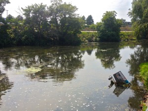
- Scajacuada Creek, with expressway in background.

Over the course of the next few months, I will explore the history of the Creek and Expressway, the current campaigns regarding their improvements, and lastly, what the broader implications are for similar problems throughout the city. The series will take a closer look exhibits at Buffalo’s History Museum and Burchfield Penny Art Museum that are highlighting the issues surrounding these two campaigns, as well as the community groups and organizations driving the effort to effect change on these hot-button issues.
Looking back at these mistakes, however, the intent is not to assign blame. Instead, with 100 years of urban planning blunders, this series, and these campaigns, are about learning from previous lessons, and creating a Buffalo that we not only want, but that we deserve.
Like the “UrbEx” bloggers who trucked through three-miles of sewage and stagnant water that currently defines the Scajacuada Creek, the goal is not to criticize and complain, but to understand and improve, so that maybe the future of the creek, and expressway, wont be as dark as the caverns that wind beneath Buffalo’s East Side.
This piece also appeared on the Buffalo Exchange.
No comments:
Post a Comment